Visited: June 15th to 22nd, 2026. Published August 23, 2026
The Island
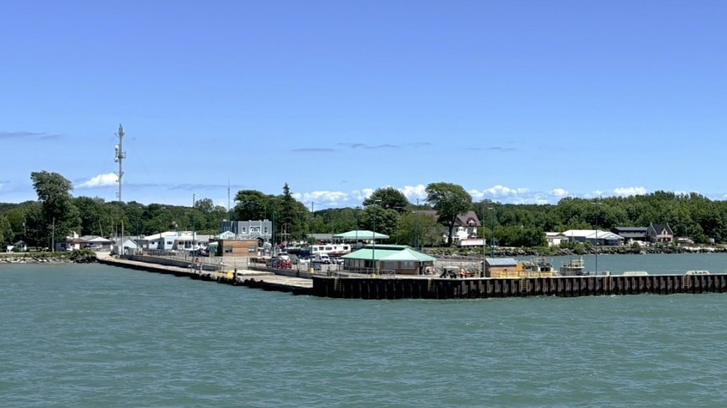
There is no real downtown on Pelee Island; just quiet pockets of life spread between farmland, shoreline, and the ferry dock
Our hosts, along with many online commenters, strongly recommended bug repellant was an absolute must when visiting Pelee Island. They warned that blood sucking stable flies, swarming mosquitoes and the always annoying fishflies would be part of the welcoming committee. We arrived with our highest level of old school deet supply. Why so many bugs in the middle of nowhere?
Pelee Island, a birdwatcher’s paradise, sits almost halfway between the province of Ontario and the state of Ohio, a perfectly situated rest stop for hungry migrating birds. Surrounded by water and containing rich interior wetlands makes it a highly effective bug producing environment. From the bird’s standpoint, it is an all you can eat buffet. From the bug’s standpoint, we were on the menu.
Pelee Island is the largest island in Lake Erie and is Canada’s southernmost populated place. Accessible by car ferry in summer months and private airplane throughout the year, its permanent population is a little over 200 people. Come summertime, the 1 ½ hour ferry crossing welcomes seasonal residents and short stay visitors. Reports show the island’s population then increases to 2000 people. Not bad for a 16 square mile island. Comparatively speaking it is the same size as Santa Monica, California. And speaking of California, it may surprise many that Pelee Island and Northern California are on the same 41st parallel north. On the other side of the Atlantic, it lines up in the centre of the world’s most well known grape growing regions in Italy, Spain, Portugal, and Greece. So yes, there is wine here. But there is so much more here than I expected.
The Cottage – sunset, stillness and a sparkle

Even after the ferry arrives, only three or four cars drive north along West Shore Road. Within minutes, the road is quiet again.
A perfect blend of tranquility, nature and magic of night. Location made this cottage work for us. An older two-bedroom rustic cottage with large windows let fresh spring air flow through. Surrounding the cottage were mature trees and songbirds to awaken us to another day of adventure. An enclosed west facing porch provided us with evening sunsets while sipping red wine. To the east, our backyard, a farmer’s newly planted soybean field gave us a clear view of the eastern sky. On the north side, a tree line denoted the property for a vacant lot and then beyond that, more farm fields. Separated by more trees to our south were Ron and Lynn, our hosts.
Our centrally located cottage was perfect for our 7-day island discovery. From here, we were easily able to come and go between daytrips. Our daily outings allowed us, if only for a short week, to inhabit the island; not just drive through and click a picture. Safe for one afternoon of rain, we had Goldilocks weather.
One morning, I lay on the backyard deck, looking up and listening to songbirds feeding in red mulberry trees. The more I listened, the more they sounded like an orchestra tuning up—cardinals, robins, finches, and now and then a Carolina wren, each doing its own thing all at once. A cardinal whistles, another answers from the tall tulip tree. A robin chimes in from the lawn, and the finches flit about in quick bursts of chatter. It seemed random at first, just noise, but it all blended into something unexpectedly beautiful. Behind it all, I could hear Lake Erie waves rolling onto shore and the wind moving through the trees; like everything was part of the same soundtrack.
There was one night that caught me by surprise. In our PJ’s and ready for bed, I looked out into the backyard. It was so dark, it was pitch black. The kind of darkness where you can barely see your hand in front of your face. By coincidence, the timing of our road trip lined up with a moonless sky. In the large city where we live, this kind of darkness just does not happen.
With a flashlight in hand, we walked out into the backyard towards the soybean field. Funny how this kind of darkness changes the familiar, safe daytime surroundings into an unfamiliar, mysterious world. We turned off our flashlight and marvelled at the void of light and sound. Looking up through the trees, I saw a light blinking in the sky. I said to my wife “look there’s an airplane with its landing light blinking.” In the city we see plenty of airplanes, but never with a blinking white light. I was so focused on that one point of light that I did not see what was actually happening. My wife said, “look around us, here in the grass and the trees.” The tiny light I could see was not 10,000 feet in the air; it was 10 feet in front of me. We were standing in the middle of a sparkle of fireflies. Wow, I had not seen fireflies like this since my early teens. What a night to remember.
Vin Villa Winery – forget the t-shirt, we got wine

Vin Villa, rising again from the ashes and overgrowth that once buried it
Vin Villa is one of the most important historic sites on Pelee Island.
Founded in 1866, it quickly became Canada’s first commercial winery, producing award‑winning wines that gained international attention. Its greatest achievement came at the 1878 Paris World Fair. Here, Vin Villa earned a bronze medal, making it the first winemaker in Canada to receive worldwide recognition. The win opened the doors to all other Canadian producers.
We met, Riley, our tour guide at the Vin Villa estate ruins. What survives today are portions of the exterior limestone walls and the cellar, hinting at the site’s grand past. Riley explained how by 1920 the winery had ceased operations at this location, leaving the neglected site to crumble into a state of disrepair. The building sat empty, degrading for decades. As is the fate of abandoned buildings it became the haunting grounds for local kids; a place to hang out. I think it might be safe to say many of us have experienced the thrill, mystery and maybe a little ghost hunting when entering old buildings. In 1963 a fire took down what remained of the rotting roof and second floor. Remarkably, the underground cellar survived fire damage. Being completely open to all weather and environmental reclamation, what remained was almost unrecognizable. Riley, shared photographs of how the limestone mansion stood in its heyday. For years afterward, Vin Villa stood as a decaying shell.
In the 2010’s work began to restore Vin Villa as a historic site. A canopy of dense bush, overgrown trees and invasive vegetation had entombed the once remarkable establishment and its story. After opening it up to the light, workers were commissioned to stabilize and restore the limestone walls. Several feet of mud, decomposing matter and murky water was pumped out of the cellar. Some workers reported snakes had taken up residency there. Rubble was removed from the site. The property was cleared of trees that had naturally reforested the once long, open vistas to Lake Erie.
A decade after work began, Vin Villa welcomed visitors to reclaim its place in history. Our group of twenty was invited into the restored wine cellar. Entering through a set of reproduction steel doors we felt the coolness of the underground cellar. Walking deeper into the cellar our eyes adjusted to see the original limestone walls and the curved vaulted ceiling. Looking at the original limestone floor where the bases for the wine barrel bays once stood was like footprints leading into history.
Before you ask, no there is no wine stored here, but we did get a tasting in homage to Vin Villa’s historic legacy. At the end of the tour, we bought bottles of their red and white offerings. The purchase is more than a souvenir; it directly supports the preservation and continued revival of Vin Villa.
Lighthouse Point – a beacon, now a legacy

This tower once watched schooners and steamers fight the lake. Today, freighters glide past its century‑old lookout
At one time it warned ship captains away from shallow, rocky shores; now the restored tower invites us to explore the northeastern tip of the island.
No visit to Pelee Island is complete without photographing the lighthouse. The restored 36-foot-tall structure topped with its red light calls out to look deeper into its past.
Historical records show that not long after construction, the tower began to settle and developed a lean of about 1.6 degrees to the southwest. If you stand back, with a sharp eye you can see a one-foot deflection. This happened because the lighthouse was built on a shallow, sandy foundation, which could not fully support the weight of the structure. The lean is not dramatic like the Leaning Tower of Pisa at 4 degrees, but it is noticeable enough that early keepers complained about structural settling.
Looking at the tower from a distance, it appears the tower is constructed from stone. Pictures online and ones I’ve taken certainly look like the tower has a stone exterior; in reality it is wood cladding. Had heavy stones been used during the construction of the lighthouse, the sandy base would have given way, thereby causing the tower to tumble over.
Dykes and Canals – three islands become one

A glimpse of Pelee Island’s canals, carved through its reclaimed wetlands
Pelee Island has a total of 48 km of roadway made up by a 50–50 split of paved and dirt roads, 28km of which travels along its shoreline. No matter where we travelled, we inevitably drove along a canal or crossed over a canal. When we landed on the island and saw the first canal, I thought it was just a river next to the roadway. I soon realized this “river” and all the rivers had the same width and steep embankments. They all ran in a straight line; no bends or meandering through forests and meadows. Following a little light reading at our cottage, I learned these waterways are part of a dyke and canal system keeping the island’s lowlands dry. A mini-Holland if you will, only without the windmills. Judging from the great blue herons and snowy egrets we saw wading in the canals, I would say the canals were at least 10 to 20 inches deep.
I discovered Pelee Island was originally three separate land masses. The three islands were separated by three shallow, dish like marshlands, that were at the same or below the water level of Lake Erie. Folklore says back in the days before the dykes and canals were constructed, people waded across the marshes. Often, a skiff would be in tow to sell and trade goods with other Islanders. Another source said canoes were another method of crossing and were probably used more often than not compared to a skiff. I thought about men crossing over wearing hip waders, the kind a fisherman uses when fly fishing. I drifted further in thought about how anglers dream of hooking the big one is greatly romanticized. All I saw was the nightmare of being swarmed by mosquitoes.
For anyone familiar with marshland, you know mosquitos are the gift that keeps sucking. Though it probably had nothing to do with mosquitos, a decision was made to drain the marshlands. Between 1885 and 1889, Pelee Island underwent one of the largest land reclamation projects in Canadian history. Canals totalling twenty kilometers, 3 to 6 meters wide, were dredged through the marshlands. The excavated materials were placed next to the canals and on the island’s outer perimeter creating dykes up to 5 meters high holding back Lake Erie from flooding back into the former wetlands. The dredging project created roughly 5000 acres of new fertile farmland.
By 1920, the tobacco growing industry had become Pelee Island’s dominant farm crop. Tobacco was grown until the late 1980s when declining consumer demand brought it to a stop. The island’s economy had revolved around it for almost 70 years. Today, soybeans and wheat have become the main crops along with corn and hay. On our travels across the island, we saw relics of curing barns still standing in wheat fields.
The Beaches – clear, warm and hidden

Warm sunny days feel very special and happy
Because of its proximity to the ferry terminal, rental facilities and restaurants, West Shore Beach is the most used beach by day-trippers. It is also a good starting point for a shore walk to the most southern point on Pelee Island and inhabited Canada.
During our weeklong stay we noted that the eastern shore beaches are used by seasonal cottagers and short-term rentals. East Park Campground is next to East Park Beach making it super handy for RVers. A little further north is the smaller Sunrise Beach. We found all the beaches to have long sandy stretches and warm shallow waters. We walked on every beach and decided to lay our towels down on the small, out of sight Middle Point Beach. It did not have a designated parking lot so we parked on the grassy shoulder and followed farm tractor tracks through a small woods revealing the beach. We chose a spot and unpacked our gear. We had the beach to ourselves. In all the time we spent there, no one else showed up.
The water was unbelievably clear, calm and shallow. I walked out from shore until Lighthouse Point and East Park Beach came into alignment. I estimated I would have been at least 150 feet out. Looking down at my feet, the water was still just as clear as it was at the shoreline. With my slower than a dog swimming speed, I made my way back to my towel for a snack.
This was one of those rare afternoons when time slows down and the lake feels endless. Middle Point became our quiet corner of the island; a place we would not forget.
Fish Point – shell collecting to the end
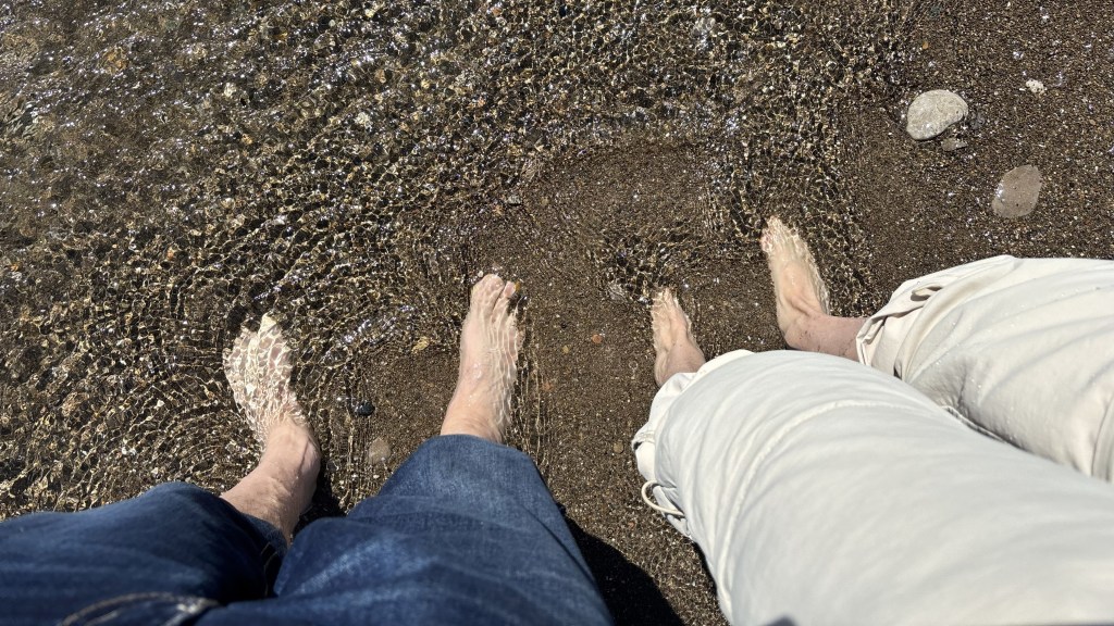
We stood at the southernmost inhabited point in Canada and let Lake Erie wash over our feet in a small baptism of victory
At the most southern end of Pelee Island is Fish Point Nature Reserve. Why is it call fish point when I did not see anyone fishing?
We visited Fish Point on two separate days. Not that it is necessary: we just got a little overzealous in our physical ability after an already long afternoon.
The first day we followed a forest trail leading to a sandy beach. Crossing over a boardwalk, I saw something move under the wood decking. “A snake, a snake”, I yelled sort of quietly not to scare off the snake, and maybe myself. It slowly slid from under the boards into short vegetation. It then turned around heading towards me. I could see it more easily now. I pulled out my phone and started a video. It must have been a meter, maybe closer to two meters long. At the cottage, I researched to learn it was an Eastern Fox Snake; a docile, non-poisonous snake. From a webpage, I read Pelee Island was anecdotally known as Snake Island; a moniker I came to appreciate as our week went on.
We continued on the trail being careful not to trip over exposed tree roots. Now mid June, the tree canopy made up by sugar maple, white ash, hackberry and chinquapin oak was well developed. The spring ground cover was mostly appendaged water leaf and Solomon’s seal which had not yet grown to full height. Trilliums were spotted, but they were already past their flowering stage. Other colourful wildflowers were in bloom. We tried to identify them using Google Lens. Unfortunately, mobile service on Pelee Island can be spotty, especially here at Fish Point.
Arriving at Fox Pond, another boardwalk carried us to the centre of the pond and the sounds of bullfrogs, but we did not make a sighting. Heart shaped spatterdock leaves with yellow flowers floating on the water surface covered a great part of the pond. An unseen chorus of bird were calling out, making positive identification difficult. We circled around to the southern end of the pond. Here, a narrow barrier dune separated the pond from Lake Erie. Our eyes followed the curve of the shoreline all the way to the sandy tip of Pelee Island. Judging the distance and feeling the weight in our tired legs, we turned back, saving the southernmost point of Canada for another day.
A few days later, we returned to Fish Point. This time, we started from West Shore Beach. Compared to the longer wooded trail, this direct route was shorter in distance, but longer in time. For meandering beachcombers like us, it made the walk even longer. We picked up sea glass, seashells, driftwood and pretty rocks. Our pockets were overflowing with souvenirs. In the distance we saw a committee of turkey vultures on the beach. As we approached, the narrow shoreline did not provide enough passing room for their comfort. They flew up, circled around and returned to the same place they had been. I wondered if they were nesting in the protected forest section at Fish Point. Birds use Pelee Island as a rest stop before making their migratory passages. Franklin’s gull, sandpipers, tree swallows and Carolina wrens were just some of the birds we saw that day. At one point we even saw a pair of pelicans, a rare sighting for us.
Making a long-left turn, the narrow sand spit jutting far into Lake Erie came into view. Of the five Great Lakes, Lake Erie is the shallowest. Here, at the south side of Pelee Island the offshore water depth is recorded at 4 metres. Looking at the sand spit, I saw why it is called Fish Point. As explained by our hosts, Fish Point shifts the way a fish’s tail flicks through water. Wind pushes sand along the shore to build the spit outward, while waves wash over it and carve new curves, just like currents reshaping a tail’s outline as it moves. Each storm or change in lake level bends, thins, or shortens the spit, giving it a new tail shape; the reason it is called Fish Point.
In the distance we could see the point where the last bit of sand vanishes into open water. Barefoot, we strolled on the flat, always narrowing sand spit. Flocks of birds were roosting ahead of us having laid claim to their place in the sun. With every step, it felt like we were gatecrashing their beach party. Some shore birds raced ahead of us as if guiding us forward to our destination. In time, the sand dropped off into the lake. We arrived at the tip; all around us open water. According to geographic coordinates on our phones, we walked 1060 metres out on the sand spit to the southern most inhabited point in Canada. How many people can make that claim? The southern most point in Canada is just 4 kilometers further south; an uninhabitable island called Middle Island. We waded out into the lake celebrating our feat by getting our feet wet. Bucket list checked.
Bug Reality Check – not what we expected
Before travelling to Pelee Island, everyone warned us about the bugs. They said, “Bring DEET, the stable flies will eat you alive.” We arrived fully armed with old‑school bug spray, ready for battle; but during our entire stay, we did not encounter a single biting insect. The only bugs that truly made an appearance were the fireflies, (magical not menacing), and the fishflies; which are more of a harmless nuisance than anything else. For us, Pelee Island turned out to be far gentler than its reputation.
By the end of our week, Pelee Island felt less like a destination and more like a place we briefly inhabited; a rhythm we stepped into and reluctantly stepped out of. From quiet beaches to firefly‑lit nights, from forest trails to limestone ruins, the island revealed itself slowly; in moments rather than attractions.


Kevin…oh my goodness. A keeper of a post…a place I’d love to visit and I know hubby Paul would, too. A treat to read this morning. Thank you! Your photos are fabulous. 😉❤️😉
LikeLiked by 1 person
Thank you, Victoria. I’d like to think I drew some inspiration from Margaret Atwood, who has a seasonal home on Pelee Island.
LikeLiked by 1 person
Oof! I’d forgotten that tidbit! Thank you again! ❤️😉❤️
LikeLike
Interesting, enjoyed the read👍Sent from my Galaxy Tab® E
LikeLike
Thanks for the read,enjoyed
LikeLike
We’ve been to Point Pelee National Park several times and have been meaning to make the trip to Pelee Island one of the days. Good to know about the bug situation! I had no idea the island was originally three separate land masses. Sounds like you had a fabulous time.
LikeLike
We truly enjoyed Pelee Island. More than we expected. I’d say we lucked out with the bug issues. We’ve been to Point Pelee and dealt with those bugs. My guess is that both Point Pelee and Pelee Island share the same bugginess. It’s probably more good luck than good management. 🐛
Take the big ferry both ways. You’ll appreciate it if the waters get rough.
Thanks for checking in.
LikeLike
So happy you both enjoyed your trip!
Thank you so much Kevin for yet again sharing with us, another amazing sanctuary adventure! What a gift you have of describing the beauty of nature as if it it right in front of the reader. I could actually feel the breeze on my face, while imagining myself in deep meditation -seated in lotus on Lake Erie’s beautiful shoreline.🙏💝🥰
Nancy Noel🧘♂️
LikeLike