Trans Richmond Trail
April 30, 2021
“Two hundred and seventy-five men, 20 trucks, and 16 side-boom tractors and 12 bulldozers were fighting rock formations and streams that were putting up a valiant fight against civilization’s forward march.”
Loraine Porter, The Liberal, Richmond Hill, Ontario. March 6, 1958
During the years 1957 and 1958 work crews were building the Trans Canada natural gas Mainline. It would be the world’s longest pipeline running 3700 kms from the Province of Alberta to the Province of Quebec, a record that stood for twenty-six years until the opening of the Trans-Siberian Pipeline at 4500 kms.
The cross-country pipeline was considered an absolute must by the ruling Federal Government of Canada. It was proposed, passed and built with much political opposition. Property owners had little recourse fighting against the expropriation of land needed for the pipeline corridor. The federal government argued that the benefits of the pipeline were similar to the construction of the Canadian railway system in the mid to late 1800’s. Its routing through your town had the potential to bring expansion to existing business and the creation of new ones. Natural gas to each home became a commodity like today’s internet.
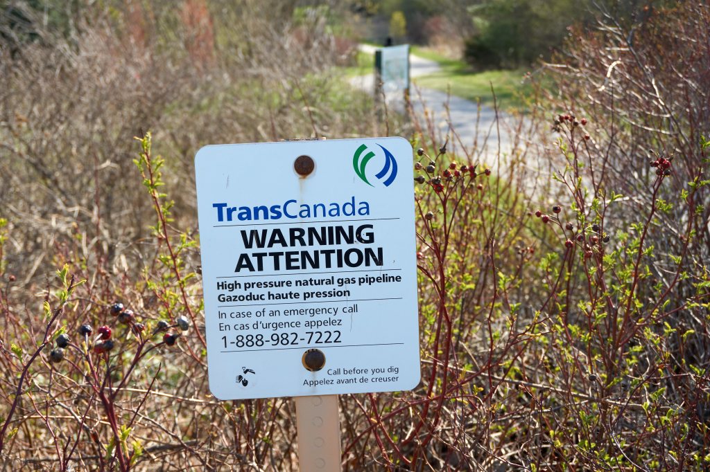
In Richmond Hill the pipeline runs south of Gamble Road in a west to east direction. It enters the City at Bathurst Street crosses Yonge Street and continues on past Highway 404 into the City of Markham. The Trans Richmond Trail follows a large portion of the pipeline between Bathurst and Yonge Streets. Many people using the Trans Richmond Trail today most likely never give a second thought to what lies underground. The scenery is what you would expect; mature trees, maintained pathways with wooden pedestrian bridges crossing rivers. The only visual clue to the six-foot deep, 24-inch diameter pipeline with natural gas rushing beneath their feet are the notification signs.
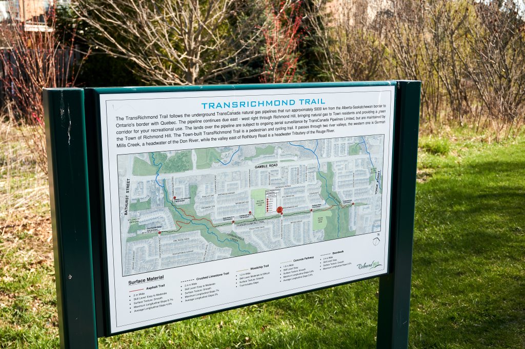
Access is made easy with several neighbourhood streets intersecting with the 2 km trail. Informational maps are placed at several of the trail entrances. Residential homes back onto the trail’s open green space and Trillium Woods Public School, William Harrison Park and Rouge Crest Park are adjacent to the trail.
Most people remain on the primary trail for walking or running while more adventurous hikers can veer off on the less travelled side paths down to one or both river valleys. This area, on the Oak Ridges Moraine is a watershed for the Humber, the Don and the Rouge Rivers, all flowing south through the Greater Toronto Area. Two of these three prominent river systems, the Don and Rouge cross the Trans Richmond Trail.
When the pipeline was constructed much less consideration was given for our natural environment compared to today. Though the pipeline was hotly debated during its construction, now it positively impacts all Canadians. It supplies fuel for heating, cooking, powering generating stations and the manufacturing of many of the products we depend on everyday.
Additional sources:
Pipeline Debate, 1956 | The Canadian Encyclopedia
Headwaters of Toronto’s three rivers Rouge, Don, Humber begin in Richmond Hill

Wonderful exciting nature trail. Thanks
LikeLiked by 1 person
Interesting! I shared this to Facebook so people in the Toronto area can see it.
LikeLike
Thank you Anne, much appreciated.
LikeLiked by 1 person